Tropical Storm Dexter: A Close Look at the Fourth Named Storm of 2025
Tropical Storm Dexter is the fourth named storm of the 2025 Atlantic hurricane season. Formed off the U.S. East Coast it is moving away from land and not expected to make landfall. Learn about its path, forecast and impacts.
8/4/20253 min read
I write this as if putting pen to paper in a weather journal, charting the path and impact of Tropical Storm Dexter. This storm has captured attention as the fourth named storm in the 2025 Atlantic hurricane season, yet it poses minimal threat to the United States coast. This blog explores its formation, forecast, impacts on Bermuda and the Atlantic, and its place within the broader hurricane season.
The Birth of Dexter
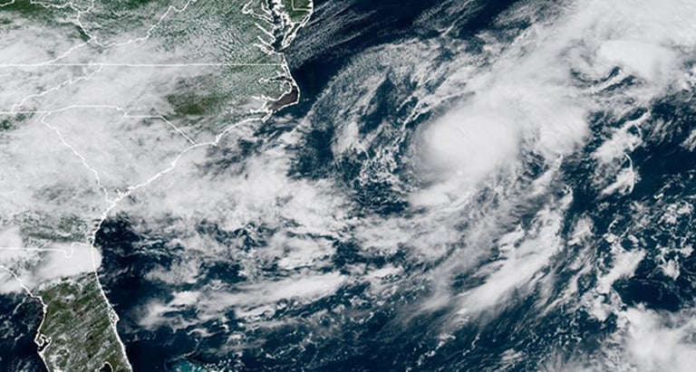
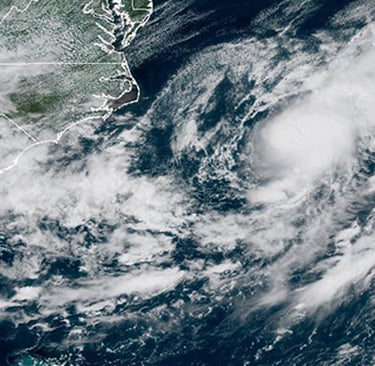
Tropical Storm Dexter formed late on Sunday August 3 in the western Atlantic Ocean, off the coast of North Carolina. It began as a low pressure system along a cold front and organized into a full tropical storm by early Monday. According to the National Hurricane Center the system swiftly met criteria for naming, earning the title Dexter and marking the continuation of what NOAA expects to be an above average hurricane season.
Key Facts at a Glance
Date of formation: Late August 3
Location: Approximately 255 miles northwest of Bermuda
Wind speed: Sustained winds near 45 miles per hour (72 kilometers per hour)
Movement: East northeast at 10 to 12 mph
Threat to U.S.: None expected
Warnings: No coastal watches or warnings are in effect
Forecast: Slight intensification followed by weakening into a post tropical system by August 6 then dissipation by August 9.
Path and Forecast: Steering into the Open Atlantic
Dexter is currently being driven by mid latitude westerly flow around the subtropical ridge positioned to its north. That motion is keeping it on an east northeast trajectory pulling it away from the U.S. coast and steering it further into open ocean. Model guidance shows general agreement that the storm will remain well north of Bermuda.
In the coming days moderate to strong wind shear and mid level dry air are expected to weaken the storm. While one model indicates the possibility of slight strengthening via trough interaction, most global guidance suggests a transition into a non tropical cyclone before eventual dissipation around August 9.
Potential Impacts: Bermuda and Atlantic Waters
Dexter is not forecast to come near the United States mainland. Coastal communities along the East Coast, from North Carolina to Florida, can breathe easier as no alerts have been issued. However, Bermuda may experience elevated surf and rip currents due to swells generated by the storm. Mariners and beachgoers in that region should remain alert for rough conditions.
While no major impact on weather alarms is expected in the U.S., the broader Atlantic basin is staying busy. The National Hurricane Center is also monitoring two other areas for possible tropical development. One is near the Southeastern U.S. coast and may cause heavy rain and coastal flooding regardless of storm formation. Another tropical wave near Africa has moderate odds of organizing into a system later in the week.
Dexter in Context: The Peak of Hurricane Season
August marks the climatological peak of the Atlantic hurricane season with rising activity expected throughout early September. NOAA has forecast between 13 and 19 named storms, six to ten hurricanes, and three to five major hurricanes in total for 2025. Dexter’s arrival fits that trend, signaling a shift from low activity in June and July to a busier Atlantic basin.
Dexter is the fourth named storm to form so far this season after Andrea, Barry and a third system earlier in summer. In contrast to Tropical Storm Barry which caused flooding in Mexico and Texas, Dexter remains contained to the Atlantic with minimal threats to land.
Public Guidance and Safety Notes
No coastal warnings or watches are currently active in the United States
Bermuda officials may issue marine advisories for hazardous seas
East coast beachgoers should remain mindful of potential strong rip currents and large surf over the next few days
Residents in eastern coastal areas should remain alert to possible rainfall threats from the nearby disturbance off the Southeast U.S.
Final Thoughts and Outlook
Tropical Storm Dexter marks an early sign that the Atlantic basin is becoming more active during peak hurricane season. While it poses no threat to the U.S., it underscores the broader regional dynamics and the need to monitor surrounding systems. Bermuda and the Atlantic shipping lanes may encounter hazardous marine conditions in the coming days. The forecast consensus points toward slight strengthening followed by a non tropical transition and eventual dissipation by late this week.
As more tropical waves spin off Africa or linger near the Southeast coast, heightened vigilance and continued updates from the National Hurricane Center remain essential. Even storm systems that remain offshore can influence wave patterns or rainfall patterns along vulnerable coastal zones.
Stay weather aware, respect offshore warnings, and bookmark reliable sources for the latest forecast cones and advisories. Tropical Storm Dexter is a reminder that in hurricane season even storms that do not make landfall can impact marine travel and coastal conditions.