Tropical Storm Gil: Tracking the Storm That’s Stirring the Pacific
As the 2025 hurricane season enters full swing, Tropical Storm Gil has captured the attention of meteorologists and storm watchers across the Pacific region. While it may not be a major threat to land, Gil is a storm worth keeping an eye on — partly because of its rapid changes in strength and partly because it reminds us how unpredictable the ocean can be.
8/2/20253 min read
A Quick Formation With Fast Changes
Tropical Storm Gil was officially named by the National Hurricane Center (NHC) on July 31, 2025, after developing from a low-pressure area well off the southwestern coast of Mexico. Thanks to warm ocean waters and calm upper-level winds, it quickly gathered strength.
For a brief time on August 1, Gil was actually classified as a Category 1 hurricane, with sustained winds just over 75 mph. But it didn’t stay that way for long. Cooler water and dry air soon weakened the system, bringing it back down to tropical storm status.
These quick changes in strength are common for storms in the open Pacific, where environmental conditions can shift dramatically within a matter of hours.
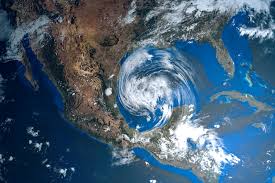
Where Is Tropical Storm Gil Now?
As of the latest updates (August 2, 2025), Tropical Storm Gil is:
About 1,250 miles southwest of Baja California, Mexico
Packing sustained winds of 70 mph
Moving west-northwest at 15 mph
Centered over open water with no threat to land
There are no watches, warnings, or advisories in place for coastal areas. That is good news for people in Mexico, Hawaii, or anywhere along the Pacific coastline.
While the storm may continue drifting across the ocean, it is unlikely to hit any populated areas. In fact, forecasters expect it to weaken even more in the coming days and possibly fade out completely by Sunday.
Tracking the Storm’s Path
Gil is currently riding along a typical Pacific storm path, moving away from the mainland and heading west-northwest into the open ocean. Forecast models suggest it will continue on this path and gradually lose strength.
Meteorologists are predicting:
No landfall
No major impact on shipping lanes or island chains
Continued weakening due to less favorable conditions
Unless something drastically changes, Gil should transition into a post-tropical system within the next couple of days. That means it will lose its tropical characteristics and simply become a remnant low-pressure area with minimal wind and rainfall.
Why This Storm Still Matters
You might wonder — if Gil isn’t hitting land — why does it matter?
Here’s the thing: every storm, no matter how small or remote, is an opportunity to learn. Weather experts study tropical systems like Gil to better understand how storms form, grow, and behave under different conditions.
In Gil’s case, we’ve already seen a few interesting things:
It intensified quickly from a tropical depression to a hurricane
It weakened just as fast, dropping back to a tropical storm in under 24 hours
It remained well-structured, with a clear core and consistent wind field, even as it weakened
These kinds of insights help improve storm prediction models for the future. They also help emergency planners and coastal communities prepare more effectively for storms that do pose a risk.
What It Means for the 2025 Hurricane Season
Gil is the seventh named storm in the Eastern Pacific this year, which puts the season slightly above average for early August.
A few things have contributed to this uptick in storm activity:
Warmer sea surface temperatures, fueled in part by ongoing El Niño conditions
Lower wind shear, which makes it easier for storms to stay organized
High humidity in the mid-levels of the atmosphere, giving storms plenty of fuel
So far in 2025, we’ve seen:
7 named storms
3 hurricanes
1 major hurricane (Category 3 or above)
2 storms that made landfall earlier in the summer
Gil, while not a threat to land, still fits the pattern of an active Pacific season.
A Reminder to Be Prepared
Tropical Storm Gil may not be dangerous, but it serves as a timely reminder that hurricane season is far from over.
The peak of the season typically runs from mid-August through October, which means stronger storms could still form in the coming weeks. If you live in a coastal area or even inland regions affected by flooding, now is the time to prepare:
Have an emergency kit ready, including food, water, medicine, and power sources
Know your evacuation route in case of a future landfalling storm
Stay informed by following local weather alerts and updates from the National Hurricane Center
Secure outdoor items, rooftops, and windows before a storm is near.
How to Follow Gil and Other Storms
Thanks to modern technology, keeping tabs on tropical storms is easier than ever.
If you want to watch Tropical Storm Gil in real-time or keep track of upcoming weather systems, here are some trusted resources:
National Hurricane Center (NHC): www.nhc.noaa.go
Cyclocane: www.cyclocane.com/gil-storm-tracker
Ventusky and Windy.com for live wind maps and forecast models
NOAA Satellite Viewer for updated satellite imagery
The Weather Channel and AccuWeather for simplified coverage
Final Thoughts: A Storm to Watch, Not Worry About
Tropical Storm Gil is not the kind of storm that will go down in history. It won’t cause destruction, disrupt travel, or leave millions without power — and that’s a good thing.
Still, it deserves attention. Not because it’s dangerous, but because it helps us learn. Every storm is a case study, and Gil is no different. Its fast formation, brief hurricane status, and slow fade into nothingness give meteorologists a lot to work with.
For now, it’s just another swirling system far out in the Pacific. But in a season that’s only getting started, Gil reminds us that the oceans are alive, the skies are changing, and it’s always smart to stay one step ahead of the storm.